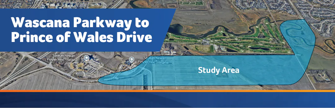
Wascana Parkway Extension to Prince of Wales Drive

The Wascana Parkway Extension to Prince of Wales Drive Functional Study explores future transportation and land use options in the area. The study will assess feasibility, impacts, routing options and to conduct comprehensive engagement before any future decisions are brought to City Council. Planning for an extension of Wascana Parkway to Prince of Wales Drive in southeast Regina dates back to City records in 1978:

  • In February 1987 Regina City Council registered a road right-of-way for the southward extension of Prince of Wales Drive to Wascana Creek.

  • In 2005, the McKell Wascana Conservation Area was created east of the planned Prince of Wales Drive extension, confirming the intent to eventually extend the road across Wascana Creek.

  • This extension is identified as part of the City of Regina's Transportation Master Plan (2017) which was approved by City Council.

  • The Wascana Parkway extension was examined as part of the 2022 Arcola Avenue Corridor Study. That study confirmed the importance of this connection for east Regina residents and identified it as a necessary alternative route during any future construction or disruptions along Arcola Avenue.

Why Your Input Matters

Consultations are ongoing with landowners, Indigenous rightsholders, community associations and other impacted parties. The information gathered from these meetings, in addition to the survey that is currently open, will assist in decision-making for any future project advancements.

A number of studies will accompany the engagement findings. These studies include geotechnical analysis (drilling and site conditions), environmental requirements (rare plant and wildlife surveys, regulation reviews, etc.), heritage analysis, traffic modeling, noise study and analysis and future costing. The results will be used to help guide future decision making about the extension and impacts to traffic flow in Regina's southeast.

The City encourages residents to fill out the survey and stay engaged through the project’s Be Heard page. You can do that by signing up to follow the project.

Design and construction will only move forward if the project proves feasible and future budget is approved by City Council.

The Wascana Parkway Extension to Prince of Wales Drive Functional Study explores future transportation and land use options in the area. The study will assess feasibility, impacts, routing options and to conduct comprehensive engagement before any future decisions are brought to City Council. Planning for an extension of Wascana Parkway to Prince of Wales Drive in southeast Regina dates back to City records in 1978:

  • In February 1987 Regina City Council registered a road right-of-way for the southward extension of Prince of Wales Drive to Wascana Creek.

  • In 2005, the McKell Wascana Conservation Area was created east of the planned Prince of Wales Drive extension, confirming the intent to eventually extend the road across Wascana Creek.

  • This extension is identified as part of the City of Regina's Transportation Master Plan (2017) which was approved by City Council.

  • The Wascana Parkway extension was examined as part of the 2022 Arcola Avenue Corridor Study. That study confirmed the importance of this connection for east Regina residents and identified it as a necessary alternative route during any future construction or disruptions along Arcola Avenue.

Why Your Input Matters

Consultations are ongoing with landowners, Indigenous rightsholders, community associations and other impacted parties. The information gathered from these meetings, in addition to the survey that is currently open, will assist in decision-making for any future project advancements.

A number of studies will accompany the engagement findings. These studies include geotechnical analysis (drilling and site conditions), environmental requirements (rare plant and wildlife surveys, regulation reviews, etc.), heritage analysis, traffic modeling, noise study and analysis and future costing. The results will be used to help guide future decision making about the extension and impacts to traffic flow in Regina's southeast.

The City encourages residents to fill out the survey and stay engaged through the project’s Be Heard page. You can do that by signing up to follow the project.

Design and construction will only move forward if the project proves feasible and future budget is approved by City Council.

CLOSED: This discussion has concluded.

If you have any questions about the Wascana Parkway Extension to Prince of Wales Functional Study you can ask them here during the online public participation portion of this phase of the project. The questions will close on June 24, 2026. 

  • What will be done to ensure pedestrians have a safe crossing at the current end of Prince of Wales? A level crossing with traffic lights will not be adequate for kids, bikes, and pedestrians.

    Mervin asked 29 days ago

    The functional study includes traffic forecasting for the future roadway and identifying potential traffic upgrades. These upgrades will not only address vehicle movement patterns, but also look at pedestrian movements, safety considerations and traffic calming measures  

  • What safety measures will be added for school kids at the intersection crossing Prince Of Wales and Assiniboine? With added vehicles to this route this is a safety concern for school kids.

    terryR asked about 1 month ago
    The functional study includes traffic forecasting for the future roadway and identifying potential traffic upgrades. These upgrades will not only address vehicle movement patterns, but also look at pedestrian movements, safety considerations and traffic calming measures. This route was explored as part of the Arcola Corridor Study, where early traffic volume forecasts indicate that traffic volumes on Assiniboine Avenue and Philip Road adjacent to W.S Hawrylak School would decrease if this extension were to proceed. 
    The City has made changes along Prince of Wales Drive to help accommodate pedestrians, including a reduced speed limit, installation of traffic signals at the Assiniboine Avenue intersection and the establishment of a new multi-use pathway along the existing road. A new traffic signal at the Wascana Gate South will also be explored as part of this study. 
  • Many kids walk home from Hawrylak so what specific safety measures will be implemented to protect elementary students at Hawrylak from the thousands of daily vehicles this road will dump into the school area?

    SamuelYao asked about 1 month ago
    The functional study includes traffic forecasting for the future roadway and identifying potential traffic upgrades. These upgrades will not only address vehicle movement patterns, but also look at pedestrian movements, safety considerations and traffic calming measures. This route was previously explored as part of the Arcola Corridor Study, where early traffic volume forecasts indicate that traffic volumes on Assiniboine Avenue and Philip Road adjacent to W.S Hawrylak School would decrease if this extension were to proceed. 
    The City has made changes along Prince of Wales Drive to help accommodate pedestrians, including a reduced speed limit, installation of traffic signals at the Assiniboine Avenue intersection and the establishment of a new multi-use pathway along the existing road. A new traffic signal at the Wascana Gate South will also be explored as part of this study. 
  • How does the city plan to mitigate the inevitable, permanent environmental destruction of the McKell Park's fragile wetlands if this project proceeds?

    SamuelYao asked about 1 month ago

    The Prince of Wales Drive extension intends to stay west of the McKell Wascana Conservation Park. The proposed road route that is being considered is consistent with the City's previous plans developed in the 1970s. Any planned roadway will ensure that the McKell conservation easement is maintained and opportunities to support the existing habitats will be considered.  

  • I have another question for the City regarding the Floodway: The City's own floodplain maps show the proposed route runs through a designated floodway, and the City's own zoning bylaw prohibits new construction in a floodway. How does the City propose to address this constraint, and what is the estimated cost of doing so?

    Eastend27 asked about 1 month ago
    The Government of Saskatchewan flood maps used by the City provided information regarding floodplain management. The City manages development through the Regina Zoning Bylaw, 2019 in and around waterways in accordance with provincial direction and regulations, to ensure safe and sustainable land use in flood-prone areas.
    Infrastructure such as roads and pathways are permitted in these floodways and the functional design will explore any regulatory and financial requirements that pertain to the floodway and considerations will be provided.  
  • My question is regarding the The McKell Conservation Area: The project page states that the McKell Wascana Conservation Area was created in 2005 'confirming the intent to eventually extend the road across Wascana Creek.' Can the City provide the specific document or agreement from 2005 that confirms this intent? The McKell family, Ducks Unlimited Canada, and the City of Regina created this area as a permanent conservation dedication, for which the City received a municipal Environmental Stewardship Award in 2009. Where in that dedication is a road referenced? There is no information anywhere that states that the road was part of the creation of the conservation area.

    Eastend27 asked about 1 month ago
    The Prince of Wales Drive extension intends to stay west of the McKell Wascana Conservation Park. The proposed road route that is being considered is consistent with the City's previous plans developed in the 1970s. Any planned roadway will ensure that the McKell conservation easement is maintained and opportunities to support the existing habitats will be considered. 

  • I am curious, has there been any environmental study done to confirm that there are no endangered species living or use the space for migratory patterns within the affected area? If so, where are the results of this study published for public viewing? If not, why hasn't this been done to confirm that the environmental impact would be minimal.

    davidrg42 asked about 1 month ago

    As part of the functional study, environmental impacts will be assessed. The contracted consulting team has experts in this field that will be exploring impacts to areas like rare plant, wildlife and heritage considerations. The findings will be included in the final report along with mitigation efforts if required.

  • I have severe concerns about the design of this survey. The questions appear structured to solicit primarily positive feedback regarding the proposed extension, while providing little or no opportunity for respondents to express concerns or identify potential negative impacts. A survey conducted in good faith should seek to understand the full range of public opinion, including both perceived benefits and drawbacks. There was not a single question asking respondents whether they have concerns about how this extension may affect surrounding landowners, land use, infrastructure, or the broader community. Why was this perspective omitted? The survey's design creates the impression that a decision has already been made and that public input is being collected simply to satisfy a procedural requirement rather than to meaningfully inform the outcome. I would like an answer to as to why it has been structured this way.

    CLV asked about 1 month ago

    The City is working with a consulting and engagement firm to assist Administration in collecting information, data and public sentiment regarding this project. The intent is to present the information in an unbiased form and to provide opportunities for everyone to share their comments. All feedback and questions are directed to the project team.

  • Question 1: If the McKell Conservation Easement cannot legally or practically be disturbed, why is the City continuing to spend public funds studying a route that may never be available for development? Qu. 2: What specific environmental impacts have been identified to date, and what threshold of environmental impact would cause Council to abandon the project entirely? Qu. 3 - City and Council list “Environmental Sustainability” as one of the three guiding principles in their 2026–2029 Strategic Plan, stating they will “consider the City’s environmental footprint and prioritize the conservation of land, water, energy, and waste minimization”. How can this be part of the strategic plan while simultaneously advancing a project that would cut through one of the few preserved wetland conservation areas in the province. This is an asset the City should be proud to champion, not destroy. Qu. 4 - Has the City obtained legal opinions regarding the viability of constructing a roadway through or adjacent to the conservation easement, and if so, will those opinions be made public? Qu 5 - Has the City had conservation with Ducks Unlimited about the land? What have been the outcomes of those conversations?

    CLV asked about 1 month ago
    The Prince of Wales Drive extension intends to stay west of the McKell Conservation Easement. The proposed road route is consistent with the previous plans that were developed in the 1970s. Any planned roadway will ensure the conservation easement is maintained.
    Data collection and consultation with interested and impacted parties is still on-going and information is still being assessed. No final decisions have been made.
  • Personally, as a daily commuter I don't see many people turning north on Ring Road from Arcola westbound in the mornings that would be diverted by a northbound on ramp at Assiniboine. The ramp at Assiniboine, while the cheapest of the options, does not seem to deliver relative value. Where is this project at in terms of detailed study? Secondly, in the Arcola Avenue corridor study there was no mention of how much traffic a northbound ramp at Assiniboine would divert. Assiniboine is a poor choice to short-cut traffic from Prince of Wales or Chuka Blvd due to its 50km/h speed limit, school zone, and residential nature. The disruption is to it is not worth the minimal value it will bring. It appears the Prince of Wales extension and Arcola widening/interchange work will bring the most value. Is there a concrete estimate of how much volumes would increase on Assiniboine without widening Arcola but adding a northbound off ramp? Lastly, It seems that the Prince of Wales / Wascana Parkway will divert the most traffic from Arcola. However, can Broad Street accommodate the additional morning traffic?

    ilewis asked about 1 month ago
    Thank you for your thoughtful comments and for sharing your perspective as a daily commuter. The Arcola Corridor Study recommended all the improvements suggested are required to achieve improvement in the traffic network in the southeast area.
    The Assiniboine Avenue northbound on-ramp with the other improvements are expected to support improvements in the following ways:
    •    Provide additional access points in and out of the southeast
    •    Reduce the safety concerns on Arcola Avenue
    •    Reduce traffic volume on Arcola Avenue
    Supported through traffic modelling, the Assiniboine Avenue northbound on-ramp is expected to provide the most benefit to the traffic network during morning and evening peaks and is expected to result in only a modest traffic redistribution across the network. 
Page last updated: 24 Jun 2026, 12:50 PM