Wascana Parkway Extension to Prince of Wales Drive

The Wascana Parkway Extension to Prince of Wales Drive Functional Study explores future transportation and land use options in the area. The study will assess feasibility, impacts, routing options and to conduct comprehensive engagement before any future decisions are brought to City Council. Planning for an extension of Wascana Parkway to Prince of Wales Drive in southeast Regina dates back to City records in 1978:

  • In February 1987 Regina City Council registered a road right-of-way for the southward extension of Prince of Wales Drive to Wascana Creek.

  • In 2005, the McKell Wascana Conservation Area was created east of the planned Prince of Wales Drive extension, confirming the intent to eventually extend the road across Wascana Creek.

  • This extension is identified as part of the City of Regina's Transportation Master Plan (2017) which was approved by City Council.

  • The Wascana Parkway extension was examined as part of the 2022 Arcola Avenue Corridor Study. That study confirmed the importance of this connection for east Regina residents and identified it as a necessary alternative route during any future construction or disruptions along Arcola Avenue.

Why Your Input Matters

Consultations are ongoing with landowners, Indigenous rightsholders, community associations and other impacted parties. The information gathered from these meetings, in addition to the survey that is currently open, will assist in decision-making for any future project advancements.

A number of studies will accompany the engagement findings. These studies include geotechnical analysis (drilling and site conditions), environmental requirements (rare plant and wildlife surveys, regulation reviews, etc.), heritage analysis, traffic modeling, noise study and analysis and future costing. The results will be used to help guide future decision making about the extension and impacts to traffic flow in Regina's southeast.

The City encourages residents to fill out the survey and stay engaged through the project’s Be Heard page. You can do that by signing up to follow the project.

Design and construction will only move forward if the project proves feasible and future budget is approved by City Council.

The Wascana Parkway Extension to Prince of Wales Drive Functional Study explores future transportation and land use options in the area. The study will assess feasibility, impacts, routing options and to conduct comprehensive engagement before any future decisions are brought to City Council. Planning for an extension of Wascana Parkway to Prince of Wales Drive in southeast Regina dates back to City records in 1978:

  • In February 1987 Regina City Council registered a road right-of-way for the southward extension of Prince of Wales Drive to Wascana Creek.

  • In 2005, the McKell Wascana Conservation Area was created east of the planned Prince of Wales Drive extension, confirming the intent to eventually extend the road across Wascana Creek.

  • This extension is identified as part of the City of Regina's Transportation Master Plan (2017) which was approved by City Council.

  • The Wascana Parkway extension was examined as part of the 2022 Arcola Avenue Corridor Study. That study confirmed the importance of this connection for east Regina residents and identified it as a necessary alternative route during any future construction or disruptions along Arcola Avenue.

Why Your Input Matters

Consultations are ongoing with landowners, Indigenous rightsholders, community associations and other impacted parties. The information gathered from these meetings, in addition to the survey that is currently open, will assist in decision-making for any future project advancements.

A number of studies will accompany the engagement findings. These studies include geotechnical analysis (drilling and site conditions), environmental requirements (rare plant and wildlife surveys, regulation reviews, etc.), heritage analysis, traffic modeling, noise study and analysis and future costing. The results will be used to help guide future decision making about the extension and impacts to traffic flow in Regina's southeast.

The City encourages residents to fill out the survey and stay engaged through the project’s Be Heard page. You can do that by signing up to follow the project.

Design and construction will only move forward if the project proves feasible and future budget is approved by City Council.

  • Engagement Update: Public Feedback

    Thank you to everyone who responded to the online survey. Given the curiosity around this project, the City received a few similar questions about this project. Below you'll find those questions and answers.

    To reiterate, this is a functional study. No decision has been made as the City and its consultant continue to work on the functional study and have conversations with interested and impacted parties.

    If you have any questions, please send them to WascanaParkway@regina.ca.

    Questions & Answers

    What is a functional study and why is it being done?

    The scope of this study is to evaluate a proposed route, identify heritage, environmental, noise and other potential impacts, gather input from interested and impacted parties, examine issues in constructing a potential road and provide a preliminary cost estimate.

    The study aims to:

    • Identify the best route for a potential roadway extension

    • Examine issues that impact the potential for construction of a roadway and identify possible mitigation needed

    • Develop a functional design, including a cost estimate and staging plan

    Why is this project being considered now?

    • This study is a follow-up to the 2022 Arcola Avenue Corridor Study, which recommended this project take place in advance of any significant Arcola Avenue upgrade.

    • This study is happening now to look at feasibility based on current conditions and respond to growing population and traffic volume in east Regina.

    • The proposed extension is just one component of a bigger, integrated approach to addressing transportation challenges in east Regina and is meant to work alongside other possible solutions.

    What does the study include?

    • Environmental surveys and assessments

    • Heritage reviews

    • Indigenous input on history and use of the area

    • Noise assessment for traffic

    • Road cross-section needs for accommodating all modes of travel (e.g., walking, cycling, transit and personal vehicles)

    • Considerations for creek crossings and floodway areas

    • Input from landowners and interested and impacted parties, along with a public survey

    How long will the study take?

    Completion is expected by December 2026, with updates provided at key milestones.

    When will construction take place?

    There is no timeline for construction at this stage, as no decisions have been made. There is also no established timeline for Administration to bring a decision to Council on the potential next steps for this project.

    Are other options, such as routing traffic to the bypass, being considered part of this study?

    No, the study is focused on evaluating this specific route option because of recommendations in earlier studies and as identified in the City’s long term Transportation Master Plan. However, alternative ideas, including suggestions from residents, are being collected throughout the process and will be included in the final report.

    Will environmental impacts be assessed?

    Environmental considerations are a key part of the study. This includes wildlife and rare plant surveys and collaboration with environmental organizations and regulators.

    Why not just widen existing roads like Arcola Avenue?

    Widening existing roads is part of the long-term transportation strategy. However, it would cause significant disruption with construction over multiple years that would mean lane reductions and traffic detours. To add a third lane on Arcola Avenue, a wider bridge would also be needed to cross Ring Road.

    This study represents a first step in a broader, long-term plan to address transportation challenges in east Regina. This explores an alternative approach that could be implemented more quickly, while the more complex and costly projects (like widening Arcola Avenue) are planned and carried out.

    Does the proposed route affect or cross the McKell Wascana Conservation Park?

    No, the proposed route will not be located within designated conservation land. The roadway right-of-way is west of the McKell conservation area. Route options are being developed to avoid conservation areas and minimize impacts wherever possible. This proposed route is consistent with the City’s historical plans and dates to the 1970s. Discussions with landowners and organizations, like Ducks Unlimited, are ongoing.

    Any potential planned roadway will ensure the McKell conservation easement is maintained and existing surrounding habitats will be supported.

    Will the study consider how this new roadway will impact schools, safety and/or local traffic?

    Yes, the project will also identify ways to minimize disruptions and maintain safety around nearby schools and neighbourhoods. The functional study will also include recommendations for safety enhancements, like signalized pedestrian crossings and traffic calming measures, particularly in areas with higher pedestrian activity.

    This route was previously explored as part of the Arcola Corridor Study, where early traffic volume forecasts showed traffic volumes on Assiniboine Avenue and Philip Road next to W.S Hawrylak School would decrease if this were to proceed.

    Will active transportation (e.g., walking, cycling) be included?

    Yes, active transportation will be incorporated into the planning and design.

    How are noise and community impacts being addressed?

    Noise levels are being studied to check if mitigation measures will be needed based on the City’s noise attenuation policy.

    How is community input being gathered?

    Feedback is being collected through the City’s Be Heard digital engagement platform using both a survey and a Q&A opportunity. There is also direct engagement with landowners and other interested and impacted parties.

    Will there be more opportunities for public participation as (or if) this project progresses?

    Yes. The intention is for the City to continue engagement with landowners and interested and impacted parties during the remaining part of the functional study. If the project is found to be feasible, engagement with the public may occur in other design phases of the project.

    Thank you to everyone who responded to the online survey. Given the curiosity around this project, the City received a few similar questions about this project. Below you'll find those questions and answers.

    To reiterate, this is a functional study. No decision has been made as the City and its consultant continue to work on the functional study and have conversations with interested and impacted parties.

    If you have any questions, please send them to WascanaParkway@regina.ca.

    Questions & Answers

    What is a functional study and why is it being done?

    The scope of this study is to evaluate a proposed route, identify heritage, environmental, noise and other potential impacts, gather input from interested and impacted parties, examine issues in constructing a potential road and provide a preliminary cost estimate.

    The study aims to:

    • Identify the best route for a potential roadway extension

    • Examine issues that impact the potential for construction of a roadway and identify possible mitigation needed

    • Develop a functional design, including a cost estimate and staging plan

    Why is this project being considered now?

    • This study is a follow-up to the 2022 Arcola Avenue Corridor Study, which recommended this project take place in advance of any significant Arcola Avenue upgrade.

    • This study is happening now to look at feasibility based on current conditions and respond to growing population and traffic volume in east Regina.

    • The proposed extension is just one component of a bigger, integrated approach to addressing transportation challenges in east Regina and is meant to work alongside other possible solutions.

    What does the study include?

    • Environmental surveys and assessments

    • Heritage reviews

    • Indigenous input on history and use of the area

    • Noise assessment for traffic

    • Road cross-section needs for accommodating all modes of travel (e.g., walking, cycling, transit and personal vehicles)

    • Considerations for creek crossings and floodway areas

    • Input from landowners and interested and impacted parties, along with a public survey

    How long will the study take?

    Completion is expected by December 2026, with updates provided at key milestones.

    When will construction take place?

    There is no timeline for construction at this stage, as no decisions have been made. There is also no established timeline for Administration to bring a decision to Council on the potential next steps for this project.

    Are other options, such as routing traffic to the bypass, being considered part of this study?

    No, the study is focused on evaluating this specific route option because of recommendations in earlier studies and as identified in the City’s long term Transportation Master Plan. However, alternative ideas, including suggestions from residents, are being collected throughout the process and will be included in the final report.

    Will environmental impacts be assessed?

    Environmental considerations are a key part of the study. This includes wildlife and rare plant surveys and collaboration with environmental organizations and regulators.

    Why not just widen existing roads like Arcola Avenue?

    Widening existing roads is part of the long-term transportation strategy. However, it would cause significant disruption with construction over multiple years that would mean lane reductions and traffic detours. To add a third lane on Arcola Avenue, a wider bridge would also be needed to cross Ring Road.

    This study represents a first step in a broader, long-term plan to address transportation challenges in east Regina. This explores an alternative approach that could be implemented more quickly, while the more complex and costly projects (like widening Arcola Avenue) are planned and carried out.

    Does the proposed route affect or cross the McKell Wascana Conservation Park?

    No, the proposed route will not be located within designated conservation land. The roadway right-of-way is west of the McKell conservation area. Route options are being developed to avoid conservation areas and minimize impacts wherever possible. This proposed route is consistent with the City’s historical plans and dates to the 1970s. Discussions with landowners and organizations, like Ducks Unlimited, are ongoing.

    Any potential planned roadway will ensure the McKell conservation easement is maintained and existing surrounding habitats will be supported.

    Will the study consider how this new roadway will impact schools, safety and/or local traffic?

    Yes, the project will also identify ways to minimize disruptions and maintain safety around nearby schools and neighbourhoods. The functional study will also include recommendations for safety enhancements, like signalized pedestrian crossings and traffic calming measures, particularly in areas with higher pedestrian activity.

    This route was previously explored as part of the Arcola Corridor Study, where early traffic volume forecasts showed traffic volumes on Assiniboine Avenue and Philip Road next to W.S Hawrylak School would decrease if this were to proceed.

    Will active transportation (e.g., walking, cycling) be included?

    Yes, active transportation will be incorporated into the planning and design.

    How are noise and community impacts being addressed?

    Noise levels are being studied to check if mitigation measures will be needed based on the City’s noise attenuation policy.

    How is community input being gathered?

    Feedback is being collected through the City’s Be Heard digital engagement platform using both a survey and a Q&A opportunity. There is also direct engagement with landowners and other interested and impacted parties.

    Will there be more opportunities for public participation as (or if) this project progresses?

    Yes. The intention is for the City to continue engagement with landowners and interested and impacted parties during the remaining part of the functional study. If the project is found to be feasible, engagement with the public may occur in other design phases of the project.

  • Map of Study Area

    The City of Regina is conducting a comprehensive feasibility study for the Wascana Parkway Extension project that will determine the viability of connecting Wascana Parkway with Prince of Wales Drive. The feasibility study is a preliminary assessment which considers traffic, safety, noise, geotechnical, environmental, heritage and financial studies. It helps the City determine whether a project is practical before committing any more resources to it. The study will inform the decision-making process. No final decisions have been made at this time.

    Please see the map below of the study area for the proposed extension.
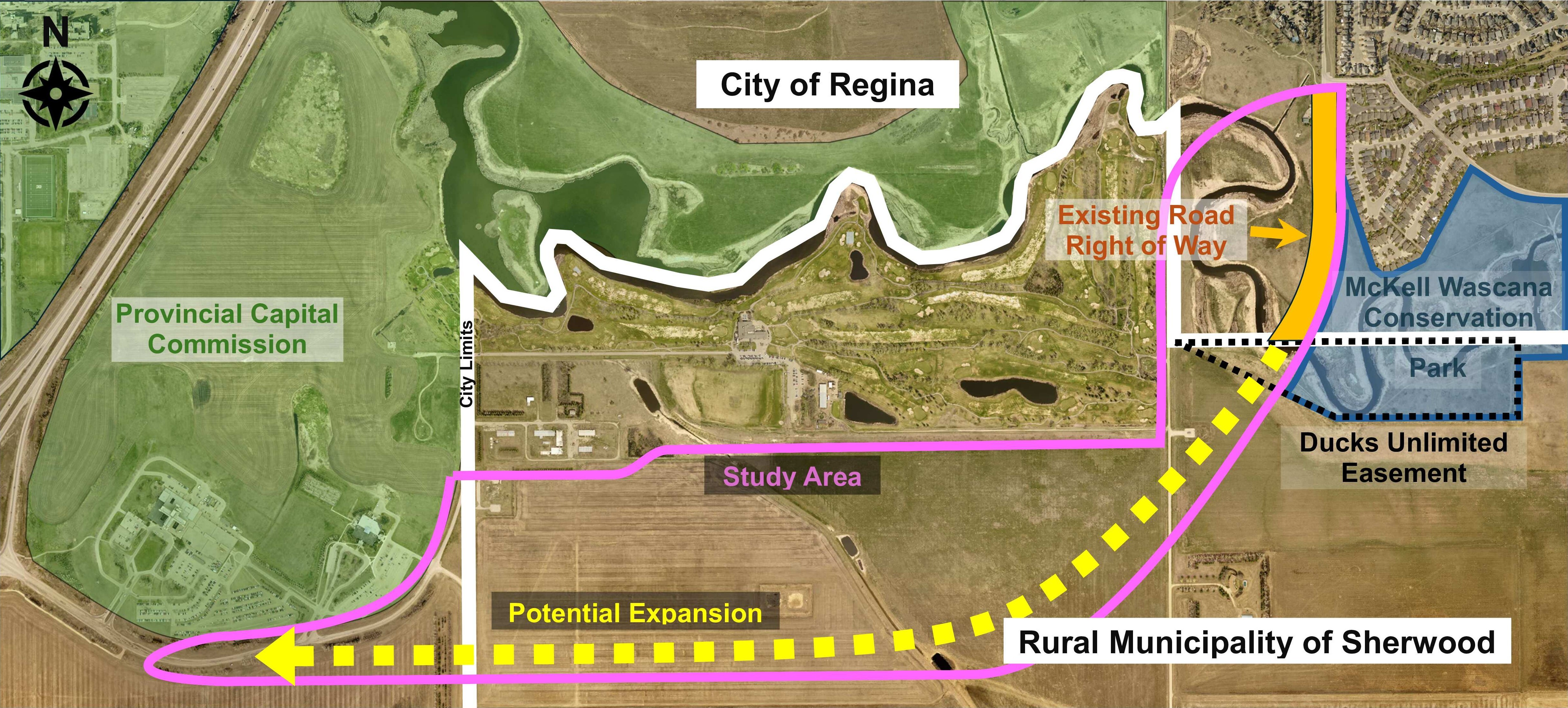

    The City of Regina is conducting a comprehensive feasibility study for the Wascana Parkway Extension project that will determine the viability of connecting Wascana Parkway with Prince of Wales Drive. The feasibility study is a preliminary assessment which considers traffic, safety, noise, geotechnical, environmental, heritage and financial studies. It helps the City determine whether a project is practical before committing any more resources to it. The study will inform the decision-making process. No final decisions have been made at this time.

    Please see the map below of the study area for the proposed extension.


  • Feasibility Study Launch

    Public participation is a central component of the Wascana Parkway Extension to Prince of Wales Drive Functional Study. Rightsholders along with interested and impacted parties — including Ducks Unlimited, the RM of Sherwood, property owners such as George Gordon Developments Ltd. and adjacent residents have already demonstrated interest related to neighbourhood impacts, environmental and heritage protection and land considerations.

    Engagement efforts will be designed to provide clear and accessible information, while gathering feedback and facilitating meaningful dialogue through a combination of meetings, engagement sessions and online tools.

    The overarching goal of community engagement for the Wascana Parkway Extension project is to ensure residents, interested and impacted parties, rightsholders and the broader Regina community are well informed, meaningfully consulted and provided with clear opportunities to share input.

    Public participation is a central component of the Wascana Parkway Extension to Prince of Wales Drive Functional Study. Rightsholders along with interested and impacted parties — including Ducks Unlimited, the RM of Sherwood, property owners such as George Gordon Developments Ltd. and adjacent residents have already demonstrated interest related to neighbourhood impacts, environmental and heritage protection and land considerations.

    Engagement efforts will be designed to provide clear and accessible information, while gathering feedback and facilitating meaningful dialogue through a combination of meetings, engagement sessions and online tools.

    The overarching goal of community engagement for the Wascana Parkway Extension project is to ensure residents, interested and impacted parties, rightsholders and the broader Regina community are well informed, meaningfully consulted and provided with clear opportunities to share input.

Page last updated: 24 Jun 2026, 12:50 PM