Expanding Citywide Housing Options
Consultation has concluded

The Expanding Citywide Housing Options project advances five planning policy initiatives outlined in the City’s Housing Accelerator Fund (HAF) Action Plan. For more information on the City's HAF Action Plan, please visit Regina.ca/HAF
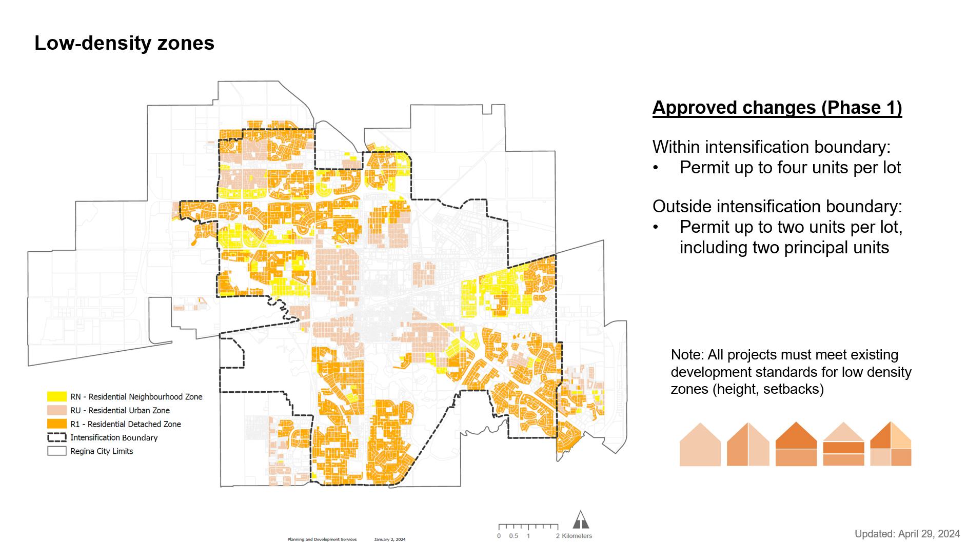
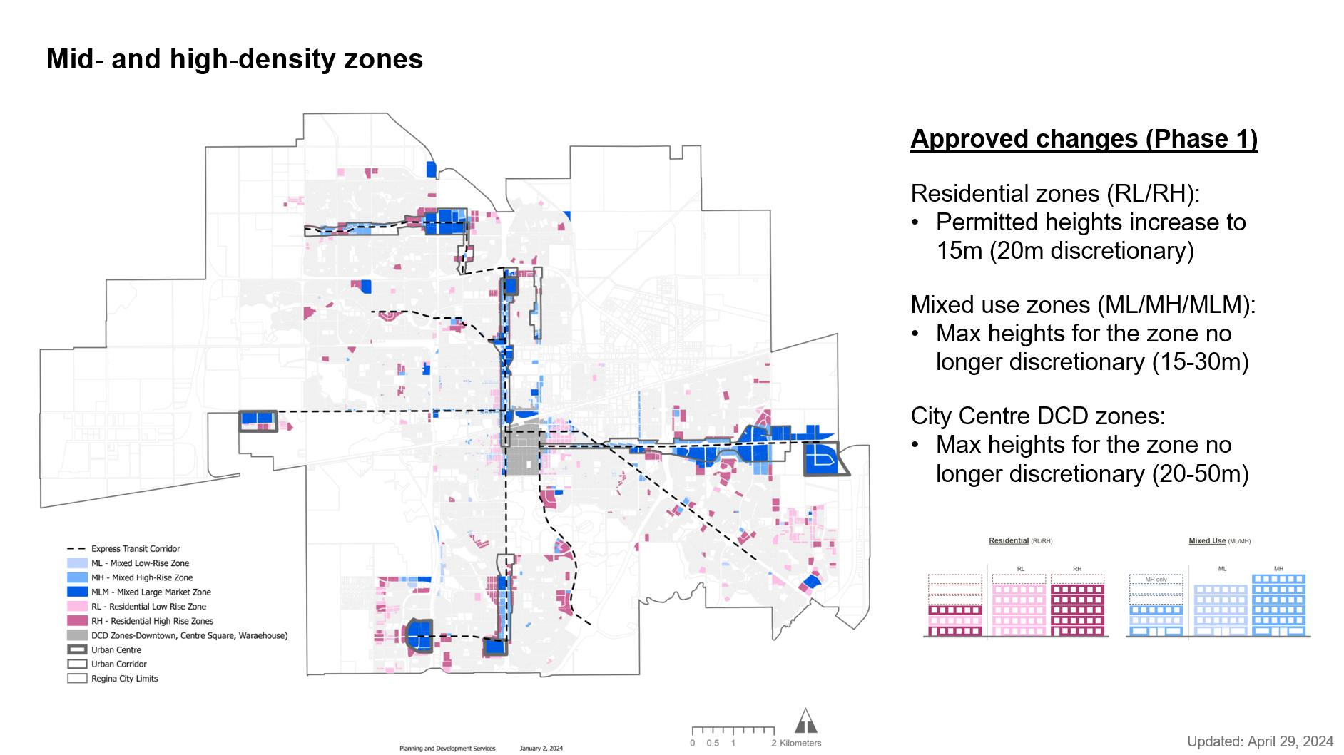
Over the last nine months, the City has approved amendments to the Zoning Bylaw and Official Community Plan (OCP) to support the delivery of diverse housing options in all neighbourhoods (see the posts in the News Feed below for additional information).
City Administration is currently undertaking additional work to advance a more consistent citywide planning approach and continue to implement the direction in the OCP.
To keep informed of future work, please sign up at the top right-hand corner of this page.
The Expanding Citywide Housing Options project advances five planning policy initiatives outlined in the City’s Housing Accelerator Fund (HAF) Action Plan. For more information on the City's HAF Action Plan, please visit Regina.ca/HAF
Over the last nine months, the City has approved amendments to the Zoning Bylaw and Official Community Plan (OCP) to support the delivery of diverse housing options in all neighbourhoods (see the posts in the News Feed below for additional information).
City Administration is currently undertaking additional work to advance a more consistent citywide planning approach and continue to implement the direction in the OCP.
To keep informed of future work, please sign up at the top right-hand corner of this page.
-
Zoning Bylaw Amendments for Considering Manufactured Homes Citywide
On March 26, 2025, City Council directed Administration to prepare a report to amend The Regina Zoning Bylaw, 2019 to allow for manufactured homes in all residential zones. This change would permit manufactured homes within neighbourhoods to increase housing options citywide.
For more information, please see our detailed Manufactured Homes FAQs here.
Manufactured Homes are currently allowed in designated manufactured home parks. Administration has been researching ways to include them in all neighbourhoods.
A report will be presented to Council at a November 2025 Council meeting. This BeHeard page has information about manufactured homes and provides a space to ask questions and get clarity on any concerns.
Consultation has concludedOn March 26, 2025, City Council directed Administration to prepare a report to amend The Regina Zoning Bylaw, 2019 to allow for manufactured homes in all residential zones. This change would permit manufactured homes within neighbourhoods to increase housing options citywide.
For more information, please see our detailed Manufactured Homes FAQs here.
Manufactured Homes are currently allowed in designated manufactured home parks. Administration has been researching ways to include them in all neighbourhoods.
A report will be presented to Council at a November 2025 Council meeting. This BeHeard page has information about manufactured homes and provides a space to ask questions and get clarity on any concerns.
-
mddl Symposium – April 2025
On April 8, mddl (pronounced 'middle') hosted a symposium at the Saskatchewan Science Centre focused on the future of middle housing development in Regina. Sponsored by the City of Regina, the event brought together homeowners, industry professionals and municipal representatives to discuss various aspects of middle housing development including design, development, municipal processes, construction and financing.
Consultation has concludedOn April 8, mddl (pronounced 'middle') hosted a symposium at the Saskatchewan Science Centre focused on the future of middle housing development in Regina. Sponsored by the City of Regina, the event brought together homeowners, industry professionals and municipal representatives to discuss various aspects of middle housing development including design, development, municipal processes, construction and financing.
-
Ongoing Work - January 2025
Following key changes to the Zoning Bylaw and Official Community Plan related to the Housing Accelerator Fund last year, the City is actively exploring new opportunities to further support the development of middle housing in central neighbourhoods. Middle housing refers to housing forms that bridge the gap between single-family homes and high-rise buildings. They are typically ground-oriented, mid-rise structures without elevator cores, such as duplexes, triplexes, fourplexes, and townhouses.
To further this goal, the City has partnered with mddl (pronounced “middle”), a team of experts with over a decade of experience in successfully delivering middle housing across Canada. mddl will assist in evaluating current policies and standards, engaging with industry stakeholders, and building capacity within the local development community to effectively deliver middle housing solutions. This collaborative effort will continue through Q1 2025, providing practical solutions to address housing needs in central neighbourhoods while fostering a more inclusive, sustainable, and diverse urban environment.
In addition to working with mddl, the City is also refining the Zoning Bylaw to improve clarity and make it a user-friendly document and reviewing Complete Neighbourhood policies to ensure best practices are incorporated into neighbourhood design.
Stay tuned for more updates on these initiatives that are shaping the future of housing in our city.
Consultation has concludedFollowing key changes to the Zoning Bylaw and Official Community Plan related to the Housing Accelerator Fund last year, the City is actively exploring new opportunities to further support the development of middle housing in central neighbourhoods. Middle housing refers to housing forms that bridge the gap between single-family homes and high-rise buildings. They are typically ground-oriented, mid-rise structures without elevator cores, such as duplexes, triplexes, fourplexes, and townhouses.
To further this goal, the City has partnered with mddl (pronounced “middle”), a team of experts with over a decade of experience in successfully delivering middle housing across Canada. mddl will assist in evaluating current policies and standards, engaging with industry stakeholders, and building capacity within the local development community to effectively deliver middle housing solutions. This collaborative effort will continue through Q1 2025, providing practical solutions to address housing needs in central neighbourhoods while fostering a more inclusive, sustainable, and diverse urban environment.
In addition to working with mddl, the City is also refining the Zoning Bylaw to improve clarity and make it a user-friendly document and reviewing Complete Neighbourhood policies to ensure best practices are incorporated into neighbourhood design.
Stay tuned for more updates on these initiatives that are shaping the future of housing in our city.
-
Future Phases of Work (2024/25)
Over the last nine months, the City has approved amendments to the Zoning Bylaw and Official Community Plan (OCP) to support the delivery of diverse housing options in all neighbourhoods. City Administration is currently undertaking additional work to advance a more consistent citywide planning approach and continue to implement the direction in the OCP. This includes:
- Reviewing the City’s Complete Neighbourhood policies;
- Reviewing the development standards and infill guidelines to support delivery of missing middle housing in central neighbourhoods; and
- Refining the Zoning Bylaw to make it user friendly.
To keep informed of future work related to this project, please sign up at the top right-hand corner of this page.
Consultation has concludedOver the last nine months, the City has approved amendments to the Zoning Bylaw and Official Community Plan (OCP) to support the delivery of diverse housing options in all neighbourhoods. City Administration is currently undertaking additional work to advance a more consistent citywide planning approach and continue to implement the direction in the OCP. This includes:
- Reviewing the City’s Complete Neighbourhood policies;
- Reviewing the development standards and infill guidelines to support delivery of missing middle housing in central neighbourhoods; and
- Refining the Zoning Bylaw to make it user friendly.
To keep informed of future work related to this project, please sign up at the top right-hand corner of this page.
-
Phase 2.2 (Neighbourhood Plan) Amendments Approved
On September 26, 2024, Regina City Council approved amendments to The Official Community Plan related to Neighbourhood Plans to support implementation of the HAF planning initiatives and advance the direction of Council. These included:
- Retaining and amending Neighbourhood Plans in new development areas (greenfield) as needed
- Retaining and amending the Downtown, Yards, and Former Diocese of Qu’Appelle Plans as needed
- Repealing all remaining Neighbourhood Plans and retaining and policies that provide relevant direction as “Area Specific Policies” in Part B of the OCP
Consultation has concludedOn September 26, 2024, Regina City Council approved amendments to The Official Community Plan related to Neighbourhood Plans to support implementation of the HAF planning initiatives and advance the direction of Council. These included:
- Retaining and amending Neighbourhood Plans in new development areas (greenfield) as needed
- Retaining and amending the Downtown, Yards, and Former Diocese of Qu’Appelle Plans as needed
- Repealing all remaining Neighbourhood Plans and retaining and policies that provide relevant direction as “Area Specific Policies” in Part B of the OCP
-
August 20, 2024: Meeting with Albert Park Community Association representatives
City staff met with the President and Vice-President of the Albert Park Community Association Board to provide information on Phase 2.2 of the Expanding Housing Options work (Neighbourhood Plan Review) and to answer questions.
Consultation has concludedCity staff met with the President and Vice-President of the Albert Park Community Association Board to provide information on Phase 2.2 of the Expanding Housing Options work (Neighbourhood Plan Review) and to answer questions.
-
August 15, 2024: Meeting with Cathedral Village Community Association representative
City staff met with the Chair of the Cathedral Village Community Association to provide information on Phase 2.2 of the Expanding Housing Options work (Neighbourhood Plan Review) and to answer questions.
Consultation has concludedCity staff met with the Chair of the Cathedral Village Community Association to provide information on Phase 2.2 of the Expanding Housing Options work (Neighbourhood Plan Review) and to answer questions.
-
July 22, 2024: Councillor LeBlanc Information Session
Councillor LeBlanc hosted an information session for residents. City staff provided an overview and presentation on the Neighbourhood Plan review followed by a Q+A session moderated by the Councillor.
There were 20-30 residents in attendance from multiple wards.
Consultation has concludedCouncillor LeBlanc hosted an information session for residents. City staff provided an overview and presentation on the Neighbourhood Plan review followed by a Q+A session moderated by the Councillor.
There were 20-30 residents in attendance from multiple wards.
-
August 12, 2024: Meeting with Al Ritchie Community Association representatives
City staff met with the President of the Al Ritchie Community Association and Executive Director of the Al Ritchie Community Centre to provide information on Phase 2.2 of the Expanding Housing Options work (Neighbourhood Plan Review) and to answer questions.
Consultation has concludedCity staff met with the President of the Al Ritchie Community Association and Executive Director of the Al Ritchie Community Centre to provide information on Phase 2.2 of the Expanding Housing Options work (Neighbourhood Plan Review) and to answer questions.
-
Phase 2.2 (Neighbourhood Plan Review) for Planning Commission Consideration
The Regina Planning Commission will be considering Official Community Plan amendments related to Neighbourhood Plans (phase 2.2) on Tuesday, September 17, 2024 as part of the Expanding Citywide Housing Options project. The report outlining the recommended amendments, which includes repealing many existing neighbourhood plans and replacing them with area specific policies, can be found here.
The deadline to register as a delegate for Regina Planning Commission is Monday, September 16, 2024, at 12:00 p.m.
Regina City Council will consider this item on Wednesday, September 25, 2024. The deadline to register as a delegate for that City Council meeting will be Monday, September 23, 2024, at 12:00 p.m.
New Documents Uploaded
Additional documents have been added to folders in the Document Section (sidebar):
- Project Documents – A document outlining housing-related neighbourhood profile data has been added.
- Council Reports – The Expanding Citywide Housing Options Phase 3 Council report has been added.
- Presentations – The Phase 3 presentation to Regina Planning Commission (PDF) and Neighbourhood Plan review presentation (PDF and recording) have been added.
Consultation has concludedThe Regina Planning Commission will be considering Official Community Plan amendments related to Neighbourhood Plans (phase 2.2) on Tuesday, September 17, 2024 as part of the Expanding Citywide Housing Options project. The report outlining the recommended amendments, which includes repealing many existing neighbourhood plans and replacing them with area specific policies, can be found here.
The deadline to register as a delegate for Regina Planning Commission is Monday, September 16, 2024, at 12:00 p.m.
Regina City Council will consider this item on Wednesday, September 25, 2024. The deadline to register as a delegate for that City Council meeting will be Monday, September 23, 2024, at 12:00 p.m.
New Documents Uploaded
Additional documents have been added to folders in the Document Section (sidebar):
- Project Documents – A document outlining housing-related neighbourhood profile data has been added.
- Council Reports – The Expanding Citywide Housing Options Phase 3 Council report has been added.
- Presentations – The Phase 3 presentation to Regina Planning Commission (PDF) and Neighbourhood Plan review presentation (PDF and recording) have been added.
Who's Listening
-
LO
Lifecycle
-
March 2023
Expanding Citywide Housing Options has finished this stageFederal Government launches Housing Accelerator Fund (HAF)
-
June 2023
Expanding Citywide Housing Options has finished this stageAdministration submits HAF application to CMHC
-
November 2023
Expanding Citywide Housing Options has finished this stageCity Council directs Administration to prepare bylaw amendments
-
January 2024
Expanding Citywide Housing Options has finished this stageCity Council approves Phase 1 amendments to The Regina Zoning Bylaw
-
April 2024
Expanding Citywide Housing Options has finished this stageCity Council approves Phase 2, Part 1 amendments to The Official Community Plan and Regina Zoning Bylaw
-
June 2024
Expanding Citywide Housing Options has finished this stageCouncil approves Phase 3 amendments to The Official Community Plan and Regina Zoning Bylaw.
-
Summer 2024
Expanding Citywide Housing Options has finished this stageReview of Neighbourhood Plans
-
September 2024
Expanding Citywide Housing Options has finished this stageProposed amendments to Neighbourhood Plans go to City Council
(Phase 2, Part 2) -
September 2024
Expanding Citywide Housing Options has finished this stageCity Council approves amendments to Neighbourhood Plans (Phase 2 Part 2).
-
2024/2025
Expanding Citywide Housing Options has finished this stageOngoing work:
- Review of the development standards and infill guidelines and monitoring.
-
March 2025
Expanding Citywide Housing Options has finished this stageCity Council directs Administration to prepare bylaw amendments to permit manufactured homes in all residential zones.
-
November 2025
Expanding Citywide Housing Options has finished this stageProposed bylaw amendments go to City Council
-
December 2025
Expanding Citywide Housing Options is currently at this stageCouncil approves amendments to allow manufactured homes in all residential zones.
Images


Documents
-
 Project Documents
-
Council Reports & Decisions
-
 CR23-70: CMHC Housing Accelerator Fund - Report to Council (June 7, 2023) (520 KB) (pdf)
-
MN23-9: Accelerating Housing Motion - Council decision (November 22, 2023) (120 KB) (pdf)
-
CR24-1: Expanding Citywide Housing Options - Phase 1 Report to Council (January 31, 2024) (5.41 MB) (pdf)
-
CR24-24 - Expanding Citywide Housing Options Phase 2 Pt 1 (9.14 MB) (pdf)
-
CR 24-24 - Council decision (134 KB) (pdf)
-
CR24-62 Phase 3 report (4.73 MB) (pdf)
-
-
Presentations
-
January 23, 2024 - Planning Commission Presentation (1.57 MB) (pdf)
-
March 26, 2024 - Planning Commission Presentation (3.36 MB) (pdf)
-
April 10 2024 - Council Presentation (5.9 MB) (pdf)
-
May 23 Overview and Update.pdf (3.92 MB) (pdf)
-
May 23, 2024 overview and update (recording on YouTube)
-
2024.05.28 RPC_Presentation (1.91 MB) (pdf)
-
Neighbourhood Plan presentation (2.56 MB) (pdf)
-
-
Manufactured Homes - FAQs.pdf (122 KB) (pdf)

